Beggars and Artisans: A Cultural History of Cork’s Franciscan Friary / A Lost Medieval Friary
- May 27, 2021
Student Exhibition, MA in Medieval History
Beggars and Artisans: A Lost Medieval Friary
Historical maps of Cork city give a clear indication about the location of the medieval Franciscan friary. UCC’s Special Collections houses a copy of the Civitates Orbis Terrarum or Cities of the World, a six-volume work, first published in Cologne and Antwerp between 1572 and 1618. The publication presents bird’s-eye views, maps and plans of all major cities of the world and its sixth volume contains a page with maps of the four Irish cities, namely Dublin, Galway, Limerick and Cork, the latter is pictured below and was the subject of the online exhibition created by the MA in Medieval History students in 2020.

The Civitates map of Cork marks the Franciscan friary with number 3 and shows it as being positioned on the north bank of the river Lee, in the vicinity of the bridge. The map is oriented east-west, so the Franciscan church features on the left, which is north, with two other mendicant churches of the Dominicans (number 4) and Augustinians (number 9) being located on the right side of the map, which corresponds to the south side of the city.
The size of the medieval Franciscan friary was restricted by topographical features of the river to the south and the red sandstone cliff to the north of the friary complex. Evidence concerning the medieval structure of the friary is limited, but its size and appearance can be discerned from documentary sources, archaeological excavations and early modern maps.
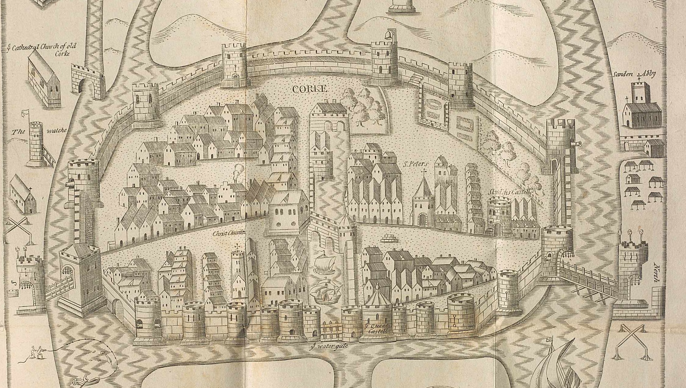
On the Pacata Hibernia map, the church of St Francis is visible on the north side of the city (right side of the map), where it is labelled as ‘Sanden Abby’ meaning Shandon Abbey. As on the Civitates map, here the church also appears as a simple structure, possibly having one nave. The Civitates map displays a side transept and the Pacata Hibernia map indicates the existence of a tower. Early modern sources, such as Annales Minorum compiled by a Franciscan historian Luke Wadding (1588-1657) state that the church was a notable one, divided in two parts by high columns, which may imply that columns separated the nave from the transept. In 1541, following the dissolution of the monasteries, the church and its tower were to be demolished: this confirms that the friary indeed had a bell tower, which was a typical architectural feature of mendicant Irish churches. The seventeenth-century Pacata Hibernia map retains the tower, in spite of chronological discrepancies regarding the tower’s demolition.
Archaeological surveys of Cork’s medieval Franciscan friary are limited, however the findings on the site of the Dominican friary of St Mary’s of the Isle provide important comparative information on the architectural structure and decorative elements of mendicant houses in medieval Cork. In both cases, a friary complex consisted of a church, most likely with one nave and a tower, and conventual buildings that were grouped around a central cloister. Cork Public Museum houses a collection of architectural fragments from St Mary’s Dominican site, such as parts of ornate window arches and funerary stone slabs.
A fragment of a double ogee-headed window, now inserted into the wall of the Distillery House on Wise’s Hill, was found in the nineteenth century near the site of the medieval friary and probably came the Franciscan house.
In 1804, during the construction of houses on the North Mall, which was the site of the medieval Franciscan friary, some stone coffins were found and subsequently recorded in 1852. The description of burials was cited in the 1917 volume of The Journal of Cork Historical and Archaeological Society: ‘The red stone rock which rises perpendicularly at the back of the buildings had on ledges at various heights coffins cut out of the solid stone, and the lid fitting so closely that to the casual observer it would appear to be part of the original rock’. The now-lost medieval Franciscan friary is still remembered in the street names, such as North Abbey Street and North Abbey Square.
By the time Father Donatus Mooney, OFM, Ireland’s minister provincial, visited all Franciscan houses in Ireland possibly between 1615 and 1616, the friary had been mostly dismantled following the dissolution of the monasteries. All that remained by that time were the ruined walls of the church and as Mooney recorded the place was ‘inhabited by an English Protestant, who has erected a dwelling house within the precincts’. As a result of the friary’s destruction, the friars of St Francis were forced to inhabit a rented house in the city.
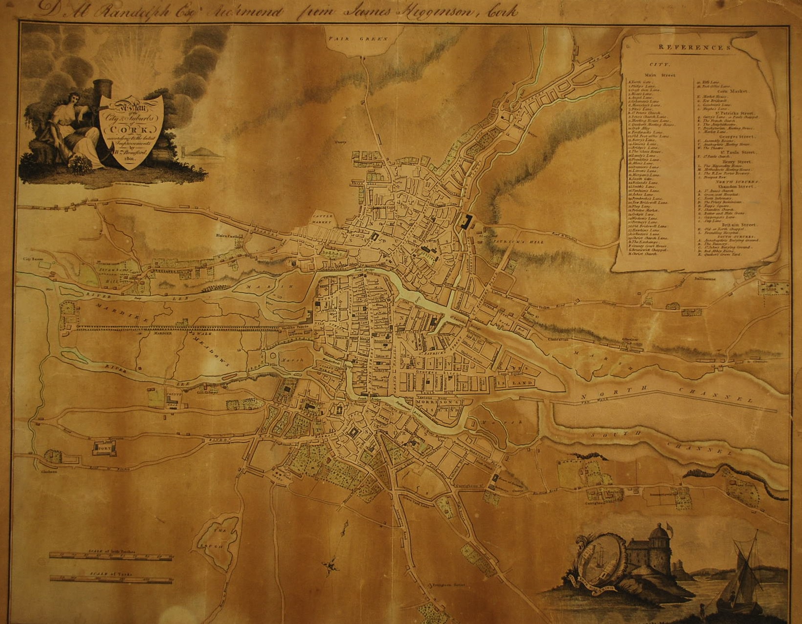
Later maps of Cork allow us to trace the subsequent history of the friary building. The 1801 map does not show the Franciscan friary, as it was no longer extent at that time, yet it displays the area where it had been originally positioned by retaining the name of North Abbey.

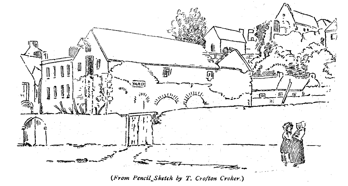
A sketch pictured below and dated to 1831 shows the remains of the Franciscan friary, which were demolished in 1836 during the construction of buildings on present-day Abbey Square. The arches pictured in the centre of the sketch were identified as remnants of the medieval friary building and may have been part of a cloister arcade.
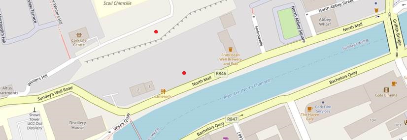
A map below (created on OpenMap ) shows archaeological sites located in the area of the medieval Franciscan friary. The two red dots mark the sites of archaeological importance: the dot placed closer to the river references the friary, the red dot north of that shows the location of the holy well.
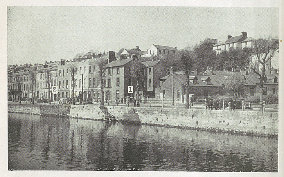
The photograph below, reproduced in the 1953 Franciscan Cork, shows the houses on the North Mall and suggests the location of medieval sections of the friary: number 1 indicates the place of arches noted in the 1831 sketch and number 2 shows the site regarded as the entrance to a Franciscan well.
Although there is no longer a physical structure on the site of Cork’s medieval Franciscan friary, place names on the North Mall recall this once prominent building that Luke Wadding described as ‘a mirror of the whole Ireland’.
Morgan Hole
Further reading
Cork City Council, Heritage Churches of County Cork (Cork, 2015).
Holland, Michael, ‘The Monastery of St. Francis at Cork’, The Journal of the Cork Historical and Archaeological Society 23 (1917), 121-125.
Hurley, Maurice F. and Sheehan, Cathy M., Excavations at the Dominican Priory: St Mary’s of the Isle, Crosse’s Green, Cork (Cork, 1995).
Kelleher, Hilary, McCarthy, Fintan and Brett, Ciara, ed., Cork City’s Burial Places: A Study of the Cemeteries, Graveyards and Burial Places within Cork City (Cork, 2011).
Mooney, Canice, ‘Franciscan Architecture in Pre-Reformation Ireland (Part I),’ The Journal of the Royal Society of Antiquaries of Ireland 85 (1955), 133-173.
Mooney, Canice, ‘Franciscan Architecture in Pre-Reformation Ireland (Part II),’ The Journal of the Royal Society of Antiquaries of Ireland 86 (1956), 125-167.
Mooney, Canice, ‘Franciscan Architecture in Pre-Reformation Ireland (Part III),’ The Journal of the Royal Society of Antiquaries of Ireland 87 (1957), 1–38.
O’Callaghan, Jerome, Franciscan Cork: A Souvenir of St. Francis Church Cork (Killiney, 1953).
